In the Valmiki Ramayana, the great Hindu epic composed around 2500 years ago, there is an interesting apocryphal story. After the abduction of Sita, wife of Ayodhya’s (in India) king Ram, his ally Sugriva, king of the Vanaras (monkey race), dispatched his forces to search for her. His search parties went in all four directions with detailed descriptions of the lands they were to explore. The party headed east was told of islands and lands beyond the sea where the sun rises, apparently called Suvarnabhumi, the “Land of Gold.”
While ancient texts refer to Suvarnabhumi as a place where traders acquired wealth, particularly gold, there is archaeological evidence that the riverbeds and streambeds of modern-day Thailand were indeed a source of alluvial gold, eroded from distant rock formations.
About a thousand years after the composition of Ramayana, around 500 AD, the Pallavas of Southern India (present day Tamil Nadu) started venturing eastwards via the sea for trade, and forged a deep connection with these lands of Southeast Asia. Their flourishing commerce of textiles, beads, semi-precious stones, and spices also exported Indian culture, religion (Hinduism and Buddhism), architectural styles (rock-cut temples), and scripts. The Cholas, who succeeded the Pallavas and dominated Southern India (~800-1300 AD), multiplied this maritime trade with Suvarnabhumi. It transformed Southeast Asia into a heartland of Hindu and Buddhist ideas – a legacy still visible today across Cambodia, Vietnam, Thailand, the Malay Peninsula, and Indonesia. The temples at Prambanan (Indonesia), Angkor Wat (Cambodia), and the vast Buddhist complex of Borobudur are remnants of this ‘golden’ period.
I have just landed at Suvarnabhumi International Airport in modern Bangkok, a bustling metropolis of 10 million people. Even on an early summer morning, the city feels hot, humid, and intense. There is movement everywhere, the roads are already choked, and a certain tropical smell pervades the air. Amidst this moment of rushed life, I think of the stillness of the city’s sacred spaces I have visited in the past, and the beauty of these opposing forces coexisting on the same landmass.
To truly understand Bangkok, it’s perhaps wise to begin with the topography. Thailand’s defining feature is the Chao Phraya River basin, covering almost one-third of the country’s land with verdant, fertile plain shaped by millennia of alluvial deposits. The Chao Phraya, or “River of Kings,” flows nearly 400 kilometers southward from the central plains to the Gulf of Thailand. Both ancient Ayutthaya and modern Bangkok lie downstream, strategically located just before the river reaches the sea.
Ayutthaya, located about 80 kilometers north of Bangkok, was a cosmopolitan capital around 1500 AD, serving as the center of an eponymous kingdom. Ayutthaya is an interesting natural ‘island’ at the confluence of three rivers (the Chao Phraya, Pasak, and Lop Buri), which provided a natural defense – a ‘moat’, before the term was claimed by capital markets. With Buddhism at its cultural core, Ayutthaya flourished through trade, drawing merchants from across Asia and Europe. It was here that the practice of digging canals (khlongs) began, to shorten trade routes by cutting across meanders in the river, making transport more efficient for merchants. Communities grew along these waterways, using them for transport, irrigation for rice fields, and daily life.
The ‘island’ of Ayutthaya (Image courtesy: Google Maps)
Ayutthaya fell to the Burmese in 1767, after which the deposed King Taksin established a new capital at Thonburi, a riverside village further downstream on the western bank of the Chao Phraya. This move laid the foundation for what would eventually become Bangkok. Thonburi was also the site of modern-day Wat Arun, which then stood as an older Buddhist temple (its present structure would be completed in the mid-1850s.) Taksin’s successor later moved the capital across the river to the eastern bank, establishing it at Rattanakosin, a site chosen for its natural partial enclosure by the river, much like Ayutthaya. The traditional practice of digging canals (khlongs) was used extensively, transforming Rattanakosin into an artificial island crisscrossed with both natural and man-made waterways, turning Bangkok into the “Venice of the East.” This was the Bangkok of late 1700s and mid-1800s, where people lived in stilt houses, commuted by boat, and shopped at floating markets. Remnants of that aquatic past still survive today – more for tourists than for trade – in places like Taling Chan Floating Market.
The banks of the Chao Phraya define modern Bangkok’s historic core: the Grand Palace, Wat Pho (Sleeping Buddha), and Wat Arun. This is the Bangkok of golden spires, monks in saffron robes, and ceremonial rhythm. Further east lies its modern commercial heart – Sathorn, Silom, and Sukhumvit – with glass towers, BTS Skytrain lines, and upscale cafes. Despite this crude description, Bangkok does not really have a ‘historic district’ or ‘old town’ tucked away for camera-toting tourists. Instead, it’s a sprawl of overlapping worlds: royal palaces and riverside temples, tangled street markets, sleek malls, roadside altars, canal-side communities, rooftop bars, and neighborhood life that hums in between like a colorful timelapse.
The banks of Chao Phraya and Bangkok's historic core: Wat Arun on the western bank, and Wat Pho and the Grand Palace on the 'island' of Rattanakosin on the eastern bank (Image courtesy: Google Maps)
As the city modernized, many canals were paved over for roads, rails, and buildings, shifting Bangkok from a water-centric layout to one dominated by land transport, along with its infamous traffic. Chao Phraya, however, remained a vital transport artery. A City Line ferry from Prannok to Sathorn offered me a charming passage through the heart of the city, and almost through time. Expert boatmen, who may have lived for generations by the river’s rhythm, dock and undock the boat effortlessly at five stops along my route, each feeling nothing longer than a metro stop. The water offers a good vantage point to see the spires of ancient temples rising along the water, followed by the gradual unfolding of modern skyscrapers as the boat moves further south. Being on a local boat suddenly takes away the rush of the city’s roads, and Bangkok’s past and present seem frozen in this skyline above water.
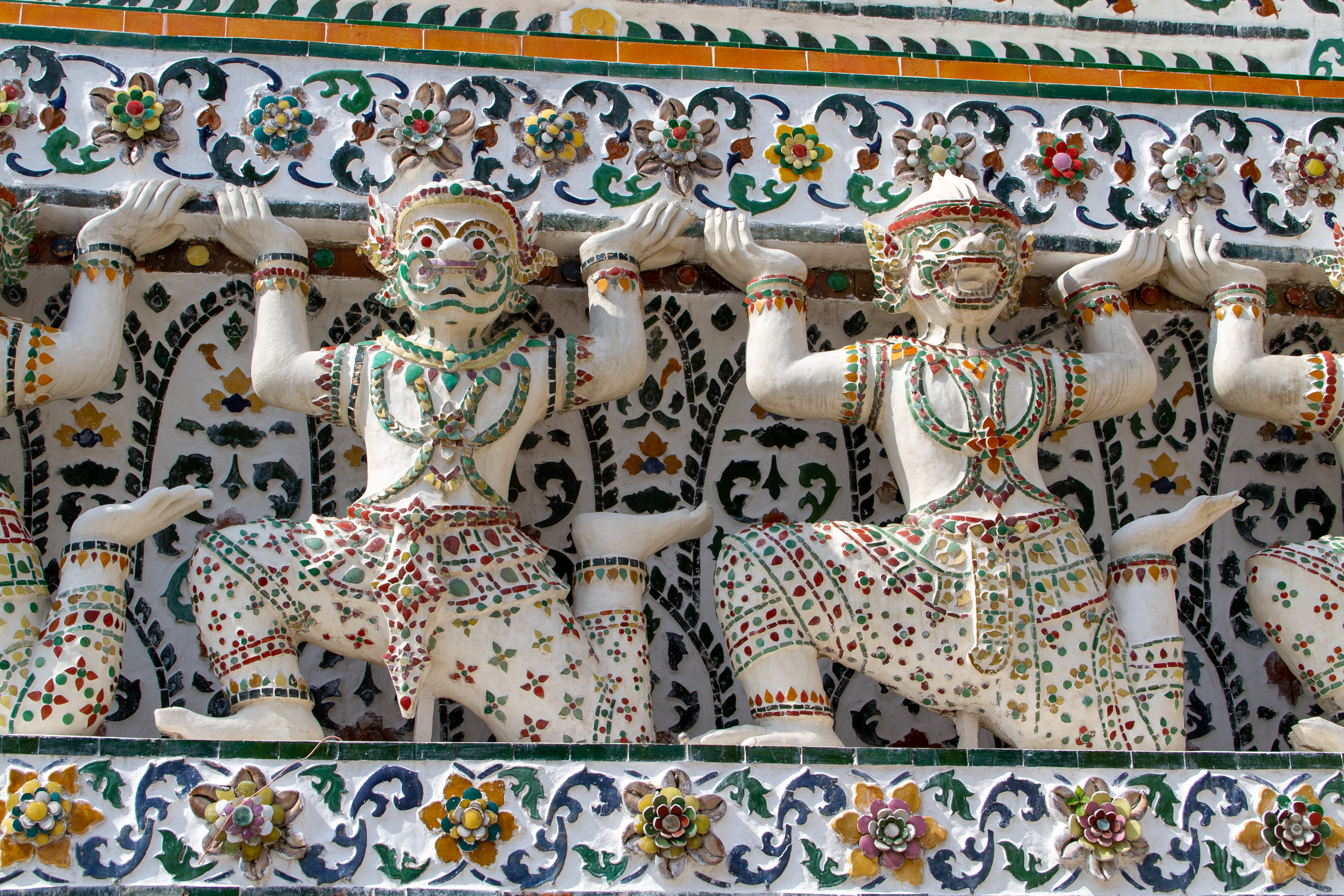
I visit Wat Arun on the western bank again, this time on a Saturday morning. The short ferry crossing from Tha Tien on the eastern bank of the river still feels like the best way to get there: the boat ride offers a phenomenal view of its distinctive 70-meter-high central prang (spire), slowly growing on one’s spirit. The whole temple complex is a curious amalgamation of Hindu and Buddhist symbolism. Primarily, it is a Buddhist temple, named after Arun, the Hindu sun god. The structure of the prang is a derivation of Buddhist pagodas but is topped by a trident, believed to belong to another Hindu god, Shiva, with the prang itself symbolizing Mount Meru of the Hindus. There are terraces that can be reached by a steep flight of stairs, dividing the structure into three symbolic levels in Buddhist iconography: the base indicating all realms of existence, the middle representing one of the seven heavens, and the top denoting the remaining six heavens. The decorations on the prang, made of colorful porcelain shards and sea snail shells, depict beautiful figurines of Yakshas (giants) and monkeys supporting it on all sides, along with prominent statues of the Hindu god Indra riding his elephant, Airavata. The temple once hosted the Emerald Buddha, the most sacred Thai icon, which was subsequently moved across the river to the Grand Palace. A hall next to the prang now houses the Niramitr Buddha. This intertwining of Hinduism and Buddhism makes me ponder upon the fluidity of religion: in the short run, it appears largely orthodox; in the long run, it survives through adaptation.
Wat Arun might also be the most photographed temple in Bangkok. Tourists flock to the “rent Thai costume” services, and nearly every photographer seems to take the mandatory shot of flowing fabric from a traditional garment worn by their subject, set against the backdrop of Wat Arun’s architecture. Local youth gather in equal numbers for wedding photoshoots, or to record TikTok reels in traditional clothing, churning the wheels of social media and the modern economy. Looking up from the base on the middle terrace, the traditional colors of Thai garments blend so seamlessly with the colorful porcelain of the spire walls and their figurines that my friend remarks, “this is a game of find-the-human.”
A close up of Yakshas on the decorated central prang of Wat Arun (Image courtesy: Shesmax, CC BY-SA 4.0, via Wikimedia Commons) My destination during this visit on Rattanakosin Island, on the eastern bank, is Wat Pho, an old Buddhist temple complex a few meters south of the Grand Palace. While the temple predates the founding of Bangkok, it was rebuilt and expanded in the late 1700s and renamed as a homage to the most sacred site in Buddhism: Bodh Gaya (the common contraction of Bodhi Tree in Southeast Asia is Bo Tree which, in turn, inspires Pho). The complex houses a large collection of Buddha images, the most popular being the 46-meter-long reclining Buddha. This figure is said to represent the Buddha’s entry into Nirvana and the end of all reincarnations. The posture is called siha-saiyas, or “sleeping lion.” The soles of the Buddha’s feet are a distinctive feature, decorated with auspicious symbols made from mother-of-pearl. Narrow hallways encircle the reclining statue, with beautiful murals adorning the walls and ceiling. The building carries a mixed energy of devotion, awe, and modern tourism. Dropping coins in the 108 bronze bowls that line the corridor, representing the Buddha’s auspicious qualities, feels more like an act of vanity than of piety. Adjacent to the building housing the reclining Buddha is a small garden with a bodhi tree, apparently propagated from the Jaya Sri Maha Bodhi in Sri Lanka, itself said to descend from the original Bodhi Tree in India under which the Buddha attained enlightenment. Whether or not wisdom spreads, religious symbolism certainly does. Something I initially thought out of place, a Thai massage center within the complex, turned out, upon further reading, to be the Wat Pho Thai Traditional Medical and Massage School, one of the earliest massage institutions in Thailand. Its teachings are also inscribed on UNESCO’s Intangible Cultural Heritage list.

Outside the sacred spaces of stillness and away from the city’s slick, modern façade, emerges the vibrant hustle of Bangkok’s streets – its narrow sois and hidden troks – where resides its authentic, pulsating heart. The sheer mass of humanity appears to be constantly in motion amidst an intimate, human-scale chaos, spilling horizontally across lanes that barely fit two, and vertically towards the skytrains and skywalks above. The sizzling woks, steaming bowls, and smoky grills are perennially on fire, with a constant slurping and chomping against the backdrop of intense smell hanging in the air – of meat, fish, vinegar, sauces, and often, incense. It’s remarkable that such a large number of humans in such small spaces rarely descends into a raucous cacophony. Instead, mutual respect subtly prevails, whether on foot or on motorbikes. Further out, on the city’s main arterial roads, luxury cars and tourist buses often queue up neatly in stagnant lanes, while motorbikes, my preferred mode of transport in the perennially stuck traffic, zip past large vehicles as gracefully as water through a sieve.
Like most ancient cities, Bangkok has witnessed the rise and fall of rulers and followers, of souls who lived, breathed, and navigated the Chao Phraya and its canals, now long gone in the cycle of life. It’s also a city that is tirelessly reinventing, while holding on to its profound spiritual and cultural roots. Bangkok is a city that defines “stillness in motion.”